/
United Kingdom
/
Scotland
/
Highland
/
Fort William
/
Touren & Aktivitäten
/


Gruppenwanderung auf den Ben Nevis ab Fort William
1 day
Zu Fuß
Gruppe
Über diese Aktivität
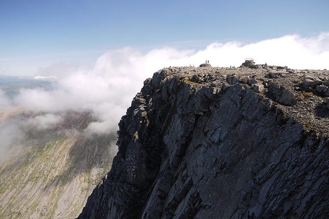
Ben Nevis ist nicht nur der höchste Punkt in Großbritannien, sondern auch die Heimat von einigen der seltensten Pflanzen des Landes, und hat seit jeher eine zentrale Rolle bei der Entwicklung des Bergsteigens auf der ganzen Welt gespielt. Besteigen Sie Ben Nevis nicht nur, sondern erfahren Sie alles Wissenswerte über seine Geschichte, Geologie, Flora und Fauna!
Wenn Sie einigermaßen fit und die Bedingungen gut sind, sollten Sie in der Lage sein, Ben Nevis in sechs bis acht Stunden zu Fuß zu besteigen – aber Sie sollten das Vorhaben ernst nehmen. Gute Planung und Vorbereitung sind entscheidend – die Bedingungen können sich selbst bei bestem Wetter dramatisch ändern.
Der Bergpfad startet in Glen Nevis und ist hin und zurück ca. 16 km lang. Er steigt auf 1.300 m an und bietet ein umfassendes Bergwandererlebnis, das robuste Wanderschuhe und gute Ausrüstung erfordert. Es kann es auf der Strecke bis Juli oder August Schneefelder geben und der Gipfel ist regelmäßig 9 °C kälter als auf Meereshöhe. Wenn es also in Fort William 18 °C ist, könnte es möglicherweise auf dem Gipfel mit Wind kalte 9 °C betragen und gefühlt noch kälter.
Mehr lesen
Weniger anzeigen
Wenn Sie einigermaßen fit und die Bedingungen gut sind, sollten Sie in der Lage sein, Ben Nevis in sechs bis acht Stunden zu Fuß zu besteigen – aber Sie sollten das Vorhaben ernst nehmen. Gute Planung und Vorbereitung sind entscheidend – die Bedingungen können sich selbst bei bestem Wetter dramatisch ändern.
Der Bergpfad startet in Glen Nevis und ist hin und zurück ca. 16 km lang. Er steigt auf 1.300 m an und bietet ein umfassendes Bergwandererlebnis, das robuste Wanderschuhe und gute Ausrüstung erfordert. Es kann es auf der Strecke bis Juli oder August Schneefelder geben und der Gipfel ist regelmäßig 9 °C kälter als auf Meereshöhe. Wenn es also in Fort William 18 °C ist, könnte es möglicherweise auf dem Gipfel mit Wind kalte 9 °C betragen und gefühlt noch kälter.
Inbegriffen
- Erfahrener Bergführer
Nicht inbegriffen
- Mittagessen
- Transport zwischen Ihrer Unterkunft und dem Start- / Zielpunkt
- Persönliche Unfallversicherung
Zusätzlich
- Sie erhalten die Bestätigung innerhalb von 48 Stunden nach der Buchung, abhängig von der Verfügbarkeit.
- Nicht barrierefrei
- Funktioniert bei allen Wetterbedingungen, bitte kleiden Sie sich entsprechend
- Diese Tour/Aktivität ist für höchstens 10 Reisende geeignet.
Merkmale
Tourismus
80%
Kulturell
55%
Originell
35%
Rezensionen

Overall speaking, it's a great day to do the summit on a whole-day hike. The ever changing weather itself is the major challenge. It is a bit disappointing that the summit peak is entirely covered by thick fog. I would say, the guide is not entirely necessary, anyone who has experience in hiking should be able to do the summit on their own, following the well-established trail.
Amazing experience! Totally worth the money! Beautiful views during the hike! Makes you feel alive;) And cheers to our guide Rachel who beside being a very nice guide really saved us with her extra gear (gloves, vest , hat and hot juice at the top) - we could not have done it without her!:)
I am 72 years of age when walking the Ben Nevis. I often go on mountain walks averaging about 2000ft ascent and 11 miles long. They are strenuous walks. Ben Nevis is twice the height. However, I have heard that a car has been driven up the Ben Nevis that gave me the illusion that there is a passable track on foot. The weather forecast for the day was not good, with heavy rain and showers forecast in the afternoon. I was kitted in rainproof clothes that was ideal for the day. It was a September day, and the weather was fine in the morning. I met the guide Rich at the starting point near the Ben Nevis Inn. There was only one other walker in our party, he was younger than me. The walk up to the wooden bridge was easy. The view was only to the west and south over the Glen Nevis valley. There are few hills further to the west and south. Farther away around the horizon there were blue mountains shrouded in stratus clouds. Beyond about 200 m elevation, the mountain track or the tourist path we followed is rugged rocky climb. I was able to keep a steady pace without a sign of exhaustion. However, I had limited strength to lift myself up when clambering up a high rise, and mentioned to the guide that there is a tendency to fall back. The walking pole was a help, yet the guide Rich said he is behind me. On this stretch of the track on the south face of the Meall an t-Suidhe we met few men laying stones to improve the path. After the rocky climb, we reached an easy saddle about halfway of the walk. The guide Rich was pleased with my ability to scramble up the rocky ascent. The camera bag swinging from the front and the pain its strap induced on the neck was a distracting impediment. To the north, there is the conspicuous Lochan Meall an t-Suidhe. I took many photographs on the way. After crossing the saddle, we headed along the long ascending path on the western face of the Carn Dearg where we also cross the Red Burn a small river, prominent feature of tourist path landscape. At the end of this long stretch, is the beginning of the zigzag path. I felt the air bit chilly but my jacket was fine for the walk, bearing in mind that jackets can make excessively hot and sweaty on mountain walks. As we continued up the zigzag track, even though the scree path was easy to walk on, I was unable to ascend continually at steady pace. I chose to stop at every corner that also served as a moment to take photos of the path. The pace of the walk was, sprint start that quickly slows down for a brief respite. According to the guide, we were neither fast nor slow and he was happy with our pace. After the zigzag, we conquered an ascent straight up, and reached the Ben Nevis summit plateau covered in boulders. The guide showed us two gullies on the north face. On the summit, there are ruins of a hotel, remnant room of the old observatory, and the Trig Point built on a pedestal at an altitude of 1344 m. We took 4.5 hours to ascend. The summit was misty as seen on the photos. Visibility was good for the eye, however not for the camera. Mist was pronounce around the summit, there was no view of scenery around the summit. After a short stop for lunch, we started a brisk descent. On the lower part of the zigzag path, we met the forecast rain. It did not last long and I was able to continue taking photos. On the descent over the rugged rocky track, I felt a pain in the calves that was not a usual symptom. The usual pain in the feet was pronounce. Rocks can be slippery. The legs were teetering on the verge of instability. The walking pole is more helpful in the descent and virtually indispensable for me. We descended in 3.5 hours. Unusually, I did not feel any pain or discomfort after we returned to the base or on the following day. With regard to the story of car driven up the Ben Nevis, there is no evidence of this. However, there is a film clip on YouTube of a Ford model T driven down the snowy Ben Nevis in the 1911.
Connor was AWESOME! Loved him! Very knowledgeable and surefooted but fun at the same time. Great day even if it did rain. Part of the charm!
Wonderful tour. I will certainly recommended to friends of mine with a similar hobby